Tectonic Plate Boundaries (detailed) — free printable diagram
Free science resource for teachers · CC BY-NC 4.0
About this illustration
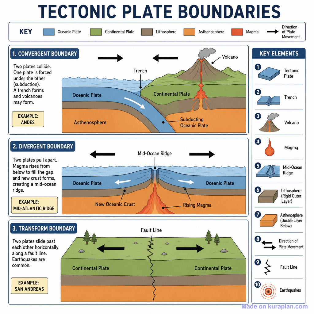
A detailed, fully-labelled educational diagram illustrating the three types of tectonic plate boundaries: Convergent, Divergent, and Transform. Each boundary type is shown in a separate panel with directional arrows, cross-section illustrations, key structural labels, and real-world examples. A top key explains colour coding (Oceanic Plate, Continental Plate, Lithosphere, Asthenosphere, Magma, Direction of Plate Movement) and a right-hand 'Key Elements' legend numbers 10 structural features. The Convergent panel shows subduction of an oceanic plate beneath a continental plate forming a trench and volcano (example: Andes). The Divergent panel shows two oceanic plates pulling apart at a mid-ocean ridge with rising magma forming new oceanic crust (example: Mid-Atlantic Ridge). The Transform panel shows two continental plates sliding horizontally past each other along a fault line causing earthquakes (example: San Andreas).
How to use
- 1Right-click the image and choose “Save image as”, or use the download button.
- 2Use it in your classroom worksheets, slides or printables — free under CC BY-NC 4.0.
- 3Attribute as “Image by Kuraplan” or link back to kuraplan.com. Not for commercial resale.
Make worksheets with images like this
Kuraplan's editor has the full image library built in — drag-and-drop into a worksheet in seconds.
Browse by subject
18 subjects · 4,851 free illustrations
Maths
1,895 free illustrations
Cross-Curricular
835 free illustrations
English
612 free illustrations
Geography
549 free illustrations
Health
200 free illustrations
social_studies
177 free illustrations
Religious Education
139 free illustrations
Music
128 free illustrations
Art
66 free illustrations
Drama
56 free illustrations
social_sciences
48 free illustrations
History
47 free illustrations
arts
26 free illustrations
pe
25 free illustrations
te_reo_maori
24 free illustrations
tech
16 free illustrations
culture
7 free illustrations
languages
1 free illustrations