World Biomes Map — free printable diagram
Free geography resource for teachers · CC BY-NC 4.0
About this illustration
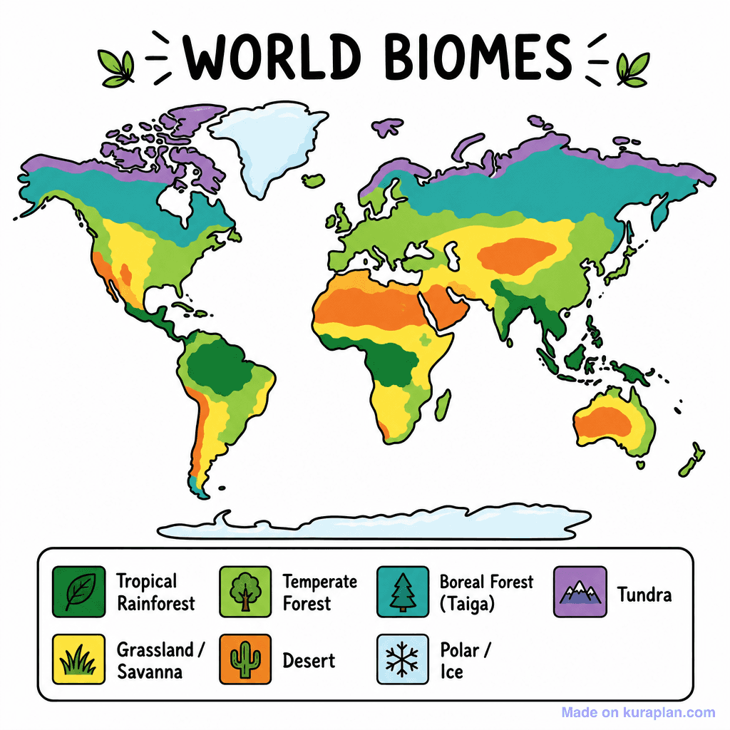
This is a flat illustration of a world map depicting the distribution of Earth's major biomes using a vibrant color scheme. The map is clearly titled "WORLD BIOMES" at the top, with a corresponding legend below outlining seven biome types: Tropical Rainforest, Grassland/Savanna, Temperate Forest, Desert, Boreal Forest (Taiga), Tundra, and Polar/Ice, each with an icon and specific color. This educational image is ideal for teaching geography, environmental science, and biology concepts related to global ecosystems. It suits classroom activities like slide presentations, reference material for worksheets on climate zones, or as a visual aid for discussions on biodiversity and environmental habitats. The visual style features bold outlines and distinct, high-contrast colors, making it easily discernible for K-12 students.
What the world biomes map shows
A biome is a very large region defined by its climate and by the communities of plants and animals adapted to live there. This map shows where the major biomes fall across the world, colour-coded, with a key. Because climate is what defines them, biomes appear in broad bands that follow latitude rather than following country borders.
- What defines a biome
- Climate — chiefly temperature and rainfall
- Tropical biomes
- Rainforest, savanna
- Dry biomes
- Hot desert, cold desert
- Temperate biomes
- Temperate forest, grassland, Mediterranean
- Cold biomes
- Boreal forest (taiga), tundra, polar
- Aquatic biomes
- Freshwater and marine
- Biomes run in bands because temperature and rainfall vary with latitude. Reading the map from the equator to a pole crosses those bands in order, which makes a good first exercise.
- Tropical rainforest sits along the equator, where it is warm and wet all year.
- The great deserts cluster near 30° north and south, where dry air descends and little rain falls — the Sahara, the Arabian, the Australian and the Kalahari all sit in those two belts.
- Boreal forest, or taiga, forms a wide band across northern Canada, Scandinavia and Russia, with treeless tundra beyond it towards the Arctic.
- Altitude works like latitude: a tall mountain in the tropics can carry several biomes stacked up its slopes, which is why mountain ranges interrupt the bands on the map.
- A biome is bigger than a habitat and broader than an ecosystem. One savanna biome contains countless individual habitats — a good distinction to check students on.
How to use
- 1Right-click the image and choose “Save image as”, or use the download button.
- 2Use it in your classroom worksheets, slides or printables — free under CC BY-NC 4.0.
- 3Attribute as “Image by Kuraplan” or link back to kuraplan.com. Not for commercial resale.
Turn this image into a worksheet
This illustration is already in Kuraplan's editor — describe the worksheet you need and the AI builds it around the image in seconds.
Related illustrations
More from World Maps (Thematic)
Free worksheets on World Biomes Map
All free worksheetsBrowse by subject
18 subjects · 5,116 free illustrations
Maths
1,894 free illustrations
Cross-Curricular
835 free illustrations
Science
815 free illustrations
English
612 free illustrations
Health
200 free illustrations
Social Studies
177 free illustrations
Religious Education
139 free illustrations
Music
128 free illustrations
Art
66 free illustrations
Drama
56 free illustrations
Social Sciences
48 free illustrations
History
47 free illustrations
Arts
26 free illustrations
PE
25 free illustrations
Te Reo Māori
24 free illustrations
Technology
16 free illustrations
Culture
7 free illustrations
Languages
1 free illustrations